You want to see the Bahamas in your own way, at your own pace. Good idea! But it’s still best to have a bit of a plan and to take some local advice before you rent the car and venture out on the roads of New Providence.
First tip: don’t leave early. You’ll only be testing your patience in the island’s morning rush hour. Instead, kick back, have a leisurely breakfast downtown and plan to head out about 9:30 AM. You can use the time to look over a Bahamas Trailblazer Map – it’s free and available almost everywhere – to get a general idea of how you’re going to get around this 21- by 7-mile island.
Second tip: take your time and plan to stop here and there along the way. The British Colonial Hilton hotel, a sprawling yellow structure at the western end of the downtown core, is easy to spot and a good place to start your tour.
A Historic Beginning – It is also a place with a long and chequered past. The original Fort Nassau was built here by the British in 1697 to guard Nassau Harbor. It was attacked and destroyed six years later in a Spanish-French invasion, rebuilt in 1744, then razed in 1837 to make way for military barracks.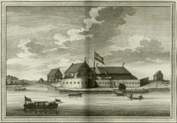
The Colonial Hotel, predecessor to the British Colonial, was built here in 1900, destroyed by fire in 1921 and rebuilt in 1922. It was recently renovated with great attention to the details of the original building. The complex now includes the Center for Commerce, home of the Bahamas International Stock Exchange.
Head east from the British Colonial Hilton along Bay St. – a two-lane, one way thoroughfare. The second building on your left, Vendue House, was the location of an 18th century slave auction. It is now home to the Pompey Museum of Slavery and Emancipation. As you drive along you will see Nassau’s bustling straw market on the left. Make a note to stop here later to check out the bargains on such things as straw hats and bags, clothing, place mats and coasters, shell jewelry and carvings – great souvenirs and gifts for the folks back home.
Shopping Mecca – You’ll notice that both sides of Bat St are lined with upscale stores. They offer duty-free prices on all manner of luxury goods: jewelry, watches, fragrances, clothing, shoes, leather goods, linens, swimsuits and much more.
At the center of the downtown stretch you’ll pass Parliament Square on the right, dominated by the statue of Queen Victoria. Flanking Her Majesty are the pink Parliament Buildings, including the House of Assembly, Senate and Supreme Court. On your left, directly across the Parliament Square, is Nassau’s centerpiece – Rawson Square, where the bust of Sir Milo Butler, first Bahamian Governor-General, is located. The square was named after Sir Rawson W Rawson, governor from 1864 to 1869.
Set a time to come back for a proper walkabout downtown. You can take a guided walking tour with a Bahamahost-certified tour guide for a minimal fee. Ask at the Ministry of Tourism’s information center in Rawson Square.
Bridges to Paradise – Continue driving east along Bay St, past the shops and restaurants. About a mile from downtown, on your left, are the two one-way bridges to and from Paradise Island. The original bridge, built in 1966, was two-way until December 1998, when the new bridge was opened, easing congestion, and streamlining access to and from the island. Under the eastern bridge is Potter’s Cay, a fish and produce market and home base for inter-island mailboats.
Make a point of coming back another time to explore Paradise Island, home to millionaires, an authentic Augustinian cloister, the famed Atlantis Resort and Casino and some of the most prestigious real estate in The Bahamas.
Driving straight on, Bay St becomes East Bay St. You’ll pass several marinas and see Nassau Harbor on your left. When the road curves to the right, look left again to see Fort Montagu on the western point of the Montagu foreshore. Completed in 1742, this fort guarded the eastern entrance to the harbor. It was named in honor of the Duke of Montagu, whose grandfather had been an ambassador at the court of Charles II. From Fort Montagu, look across the Montagu Bay to a view of the eastern end of Paradise Island.
Continue on and you will pass the Montagu fish market – a great place to pick up fresh fish and conch. Just past the fish market, East Bay St becomes Eastern Rd, which is a two-way street so remember to stay left. Eastern Rd winds along the north east coast to the far eastern point of the island. Many established Bahamian families live in fine homes along this stretch. You won’t see some of them because they have high walls but you will get an occasional glimpse. One home in particular is impossible to miss. The big white lighthouse on the left is not lighthouse at all, but a two-bedroom, two-bathroom house built to look like one.
MacPherson’s Bend – At the far eastern tip of New Providence, a bend in the road provides unobstructed ocean views, Here, you can pull off the road, much as the bend’s namesake did eighty-odd years ago.
The story goes that Harry MacPherson, owner of the first real estate company, and the island’s first car, used to park at that very spot when he was courting the woman who later became Mrs Harry McPherson. And so it became MacPherson’s Bend.
When you resume your drive, continue around the point and turn right at the second street, Prince Charles Dr. Follow this road until you reach the traffic light at Fox Hill Rd. Turn right again and continue until you reach Freedom Park, a large open area known for its Fox Hill Day parties each August. These festivities celebrate the emancipation announcement of 1834.
Back Towards Town – Continue around Freedom Part to resume driving on Fox Hill Rd, over the hill and down to Eastern Rd again, where a left turn send you back towards town. At Montagu Bay, bear left at the fish market (you’ll have to) and drive along Shirley St, a one-way street going west.
Shirley St, one of Nassau’s busiest thoroughfares, was named after Major-General William Shirley, governor from 1758 to 1768. One of the more interesting of the many historical buildings along here is the Nassau Public Library, an octagonal pink building, built between 1798 and 1799 as a prison. Soon after the library, Shirley St ends abruptly at the Central Bank, and you have no choice but to zig, zag onto Duke St, passing Government House on your left. Keep to the right, and turn right on Cumberland (switching to the left lane) to Bay St and the British Colonial, where you began.
As you pass in front of the British Colonial, keep left, as the road is now two ways. Follow the curve and head west. On your right stretches the Western Esplanade, a beach and popular picnic spot for locals. Haynes Oval, a cricket pitch where the national sport is played, is visible to the left, and overlooking this field sits Fort Charlotte, built in 1789 to guard the western entrance to the harbor.
Look right again to see Arawak City, a popular outdoor eating spot. This is the perfect place to stop for a lunch of conch salad or some fresh fish. After lunch, walk across West Bay St and enter the 18-acre Botanical Gardens on Chippingham Rd. Stroll through the 600 species of tropical flora, paying special attention to the yellow elder, the national flower of The Bahamas. If you have a soft spot for animals, walk or drive a little further up Chippingham Rd to visit the Bahamas Humane Society, and Ardastra Gardens, Zoo and Conservation Center.

Go Slow Bend – Back in the car on West bay St, put on your sunglasses, and continue west into the afternoon sun. A mile or so along brings you to Saunders Beach on your right. Soon after, the road bends sharply to the left at Brown’s Point, also known as Go Slow Bend, for obvious reasons. From here, the stunning vista across Goodman’s Bay includes Cable Beach and the hotels along the strip.
Continuing along the curving road, you approach a roundabout, and Goodman’s Bay, a public park and running track along the beach. On your left is the Cable Beach Gold Course. Drive slowly through the hotel district of Cable Beach, where crosswalks allow pedestrians’ access to the three-quarter-mile landscaped promenade down the center of the road.
At the end of the hotel strip, a residential area, combined with smaller hotels and timeshares, begins. Take time to explore some of the back streets or continue on West Bay St, through an area where casuarina trees make a sweeping arc over the road and expensive waterfront homes stretch along the shore.
A little further, a bridge allows boat traffic in and out of the canals of Sandyport, the gated community on your left. Delaporte, a waterfront residential community, sits on the point to your right. Follow a long and winding part of West Bay St along the water and enjoy the unobstructed views of the ocean to the north. Natural caves on the left side of the road tell you that you’ve reached Caves Point, both a location and a housing development on the ocean.
A Beach Called Love – Further along West Bay St, enjoy the ocean views of Orange Hill Beach until you reach the village of Gambier. You’ll know it first by the sign, and second by colorful Compass Point restaurant and hotel on the right. Continue on from here to Love Beach, named not for romance, but for the family who once owned a plantation. Views of the ocean are obstructed from here on, but the homes are worth admiring.
As you carry on along the West Bay St, you’ll reach the roundabout at Lyford Cay, an exclusive private community of canalfront homes. The development was founded by William Lyford Jr in 1788, and continues to thrive as one of the poshest neighborhoods in The Bahamas, which is why you can’t go in for a look.
At this point our tour ends, but you may wish to continue to the south side of the island, to explore South Ocean, Adelaide and Coral Harbor on your own.
To return to downtown Nassau, either retrace your route or start back along West Bay St and take the right hand fork where West Bay St splits. Drive along Windsor Field Rd to go past the airport and along the edge of Lake Cunningham on John F Kennedy Dr, onto Thompson Boulevard and then Nassau St into town.
If you’ve been taking the time to explore, you’ll be just in time for dinner at one of Nassau’s fine restaurants. Bon appetit!